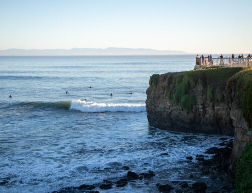
A cliff at Lighthouse Point in Santa Cruz. Erosion is causing a cave to form here, which could affect surf breaks at Steamer Lane. (Amaya Edwards — Santa Cruz Local/Catchlight Local)
SANTA CRUZ >> Surfers, scientists and city officials agree: Santa Cruz beaches have lost a lot of sand. The decline over the last several decades can be seen along much of the city’s coastline — and amid climate change-induced sea level rise, it prompts concerns about continued erosion, coastal infrastructure and threats to the city’s world-class waves.
In recent years at Its Beach on West Cliff Drive, high tides and large swells have consistently crashed over the guardrail and onto the walking path. This is typical in winter, in part because beaches are seasonal — they get wider in the summer and smaller in the winter when storms scour the coast.
But the overall depletion of sand means, in many areas the waves now strike the cliffs nearly unabated year-round and waves inundate the path more often.
“Last summer, I believe, was the first time I’ve seen that happen in the summer,” said local surf legend and surf school owner Richard Schmidt. “Its (Beach) was more depleted than I’ve ever seen for that time of year.”
Sand is critical for many surf breaks. For some spots, increased sand build-up can enhance wave quality, and in others — like Cowell’s — the break depends on sand bars forming. The eroding coastline and quality of Santa Cruz’s waves are closely linked, and as sand is depleted, coastal erosion is likely to speed up.
City leaders are weighing how to respond to these concerns. Options include reinforcing the coastline with rocks or seawalls, moving infrastructure inland or installing natural barriers such as dunes. But these come with their own costs and concerns, and for some coastal infrastructure that has already failed, such as the chunk of West Cliff Drive that fell into the ocean, these efforts were too late.
Where did the sand go?
Jon Warrick, a geologist at the Pacific Coastal and Marine Science Center in Santa Cruz, said the region’s beaches are currently among the narrowest he has seen over the 22 years he’s been there. He attributes much of the recent sand loss to powerful winter storms in 2023 and 2024 that stripped sand from beaches along the California coast.
Beaches can take years to recover from large storm events, Warrick said, and the sand loss trend isn’t just anecdotal — science confirms it.
Using new measurement techniques with satellite records, Warrick and fellow researchers have tracked how beaches change over time. New measurements have allowed them to reassess patterns in beach changes since 1984, when satellite shoreline records began. The data suggests that sand levels fluctuate in cycles, with coastlines widening and narrowing over years or even decades.
“It may be that, with the supply of sediment coming down the coast, we’re just in one of those troughs that occur once in a while,” he said.
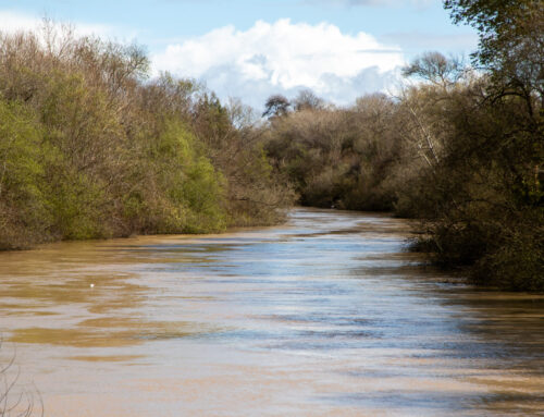
Along the Santa Cruz coastline, sand generally flows west to east before it falls into the deep underwater canyon in the Monterey Bay. Sand at Its Beach and along West Cliff originates up the north coast, Warrick said, ejected from watersheds like Scott Creek or further north near Año Nuevo State Park during periods of heavy rain.
Those watersheds are relatively undeveloped, Warrick noted, so human influence on sand flow is minimal.
It can take years — even a decade — for sediment to move down the coast and reach West Cliff. That means sand conditions at Its Beach today may reflect rainfall patterns from many years ago.
“We have to wait for that sand to get down to Its Beach,” Warrick said. “Its Beach is really responding to those wet, dry cycles, most likely over a decade ago.”

As concerns of erosion and sand disappearance amplify, famous surf spots like Steamer Lane could be vulnerable to a permanent change to the way the wave forms and breaks. (Stephen Baxter — Santa Cruz Local file)
Could erosion affect the surf?
Surfers and oceangoers have become increasingly worried about the future of surfing in Santa Cruz, especially at famous spots like Steamer Lane. Many of them have shared these concerns with city leaders, but fear the city is losing time to address the ongoing erosion.
Warrick said cliffs along the Santa Cruz coast erode at an average rate of 6 to 12 inches per year. But the more devastating losses typically occur in sudden collapses rather than gradual depreciation — visible at the Lane where chunks of cliff have fallen into the water, creating new obstacles for surfers at low tide.
Another unknown about the impacts on surf spots involves two sea caves at Lighthouse Point. Under the bluff at Lighthouse Point, waves have eroded either side into deep sea caves. As the waves continue to scour the caves and they get closer to connecting, some surfers fear it could alter the way the waves break.
“It depends on how (the caves) would fail, if they were to fail,” Warrick said.
He pointed to Natural Bridges State Beach as an example of how the coastline is evolving. The park’s famous natural arch is the last remaining from a formation that once had several.
Steamer Lane’s reefs are world-famous due to focused wave energy that delivers consistent, quality surfing breaks. But the break is shaped by interconnected factors such as sand flow and wind protection from the bluffs. Changes to the cliffs could influence how waves reflect off the cliff, how sand moves along the shore and how wind flows around the bluffs.
Schmidt, the surf school owner, is less concerned about the surf being harmed by a cave collapse. If anything, he said, it might allow sand to move more freely along the coast, which could improve conditions.
“When there’s no sand, it can get pretty treacherous getting in and out of the water. It totally affects business.”
—Richard Schmidt, local surf legend and surf school owner
Low sand affects surfing at Cowell Beach
Ed Guzman, a former big-wave surfer who founded the local surf school Club Ed, has been teaching at Cowell Beach since 1990. He said sand levels have always fluctuated, but the years with high sand build-up are becoming less frequent.
“We’ve had about six years of not very good sand (at Cowell’s),” Guzman said. “Hopefully that turns around.”
Sand from Its Beach eventually moves around Steamer Lane and helps form the sandbars that shape the waves at Cowell’s, one of Santa Cruz’s most popular beginner surf spots.
When sand levels are low, waves break only at the lowest tides, Guzman explained, which shortens the window for lessons and exposes rocks that can be hazardous for beginners. This is true for other beginner-friendly breaks, too, including 38th Avenue.
“When there’s no sand, it can get pretty treacherous getting in and out of the water,” Schmidt said. “It totally affects business.”
A report released last year by the Santa Cruz-based Save The Waves Foundation estimated that surfing contributes about $190 million annually to the Santa Cruz County economy.

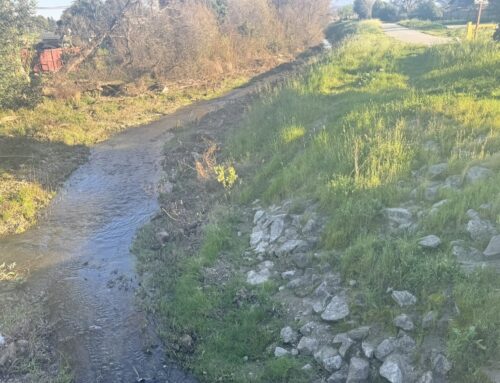
When sand levels are low at Cowell Beach, waves break only at the lowest tides. (Nik Altenberg — Santa Cruz Local file)
What can be done?
City officials are now studying long-term strategies for managing the coastline.
The “Resilient Coast Santa Cruz” initiative aims to create coastal management plans for the next 20 to 30 years. City staff, working with consulting teams that include ecologists, planners and coastal engineers, are expected to present recommendations to the Santa Cruz City Council in March 2027.
The effort is in parallel with the city’s 50-year vision for West Cliff Drive, which outlines how the stretch of coast may need to adapt to decades of cliff erosion and sea-level rise.
Tiffany Wise-West, the city’s Sustainability and Resiliency Officer, said the city is conducting additional analysis specifically for the Lighthouse Point area.
“Right now, all options are on the table,” she said, including relocating Lighthouse Field’s roadway and walking paths, “hard armoring” — such as pouring cement into the caves — or more nature-based solutions, including planting vegetation along the coast or dune restoration.
“If you want to have a beach (at Its) over the long run, then getting out of the way may be the best option.”
—Patrick Barnard, research director at UC Santa Cruz’s Center for Coastal Climate Resilience
Patrick Barnard, research director at UC Santa Cruz’s Center for Coastal Climate Resilience, said each approach has tradeoffs.
At Its Beach and Lighthouse Point, nature-based solutions may be difficult because the beach is already so narrow, he said. Meanwhile, hard structures like seawalls tend to accelerate beach erosion.
“If you want to have a beach (at Its) over the long run, then getting out of the way may be the best option,” Barnard said.
In the shorter term, the city’s five-year plan for West Cliff addresses urgent erosion projects such as seawall repairs, monitoring coastal changes and studying the feasibility of moving parts of West Cliff Drive inland.
Barnard said Santa Cruz’s challenges aren’t unique. Similar erosion issues are playing out across California where coastal development sits too close to the ocean, like Malibu and Santa Barbara. Warrick praised some developments on the south side of Half Moon Bay for building away from the coast and giving the cliffs room to erode.
“Cliffs move in one direction — they move inland,” Warrick said. “And that’s something that’s been happening for millennia along this coast. We need to think about how we work with it, or work against it.”
Questions or comments? Email [email protected]. Santa Cruz Local is supported by members, major donors, sponsors and grants for the general support of our newsroom. Our news judgments are made independently and not on the basis of donor support. Learn more about Santa Cruz Local and how we are funded.
Evan Quarnstrom holds a degree in International Business from San Diego State University. He grew up in midtown Santa Cruz.